Geolocate

Laoag topographic map

Click on the map to display elevation.

About this map

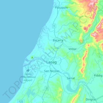
Name: Laoag topographic map, elevation, terrain.

Location: Laoag, Ilocos Norte, Ilocos Region, 2900, Philippines (18.14135 120.37557 18.30481 120.64733)

Average elevation: 135 ft

Minimum elevation: -3 ft

Maximum elevation: 1,437 ft

Other topographic maps

Click on a map to view its topography, its elevation and its terrain.

Suyo

Philippines > Ilocos Norte > Dingras

Average elevation: 128 ft

Bacarra

Philippines > Ilocos Norte

Average elevation: 79 ft

Solsona

Philippines > Ilocos Norte

Average elevation: 207 ft

Poblacion 2

Philippines > Ilocos Norte > Pagudpud

Average elevation: 39 ft

Brgy. 58- Casili

Philippines > Ilocos Norte

Average elevation: 33 ft

Bangui

Philippines > Ilocos Norte

Average elevation: 236 ft

Pasuquin

Philippines > Ilocos Norte

Average elevation: 164 ft

Paoay Lake

Philippines > Ilocos Norte > Suba

Average elevation: 85 ft

Batac

Philippines > Ilocos Norte

Average elevation: 174 ft

Suba

Philippines > Ilocos Norte

Average elevation: 92 ft

Tangid

Philippines > Ilocos Norte > Laoag

Average elevation: 30 ft

Dumalneg

Philippines > Ilocos Norte > Dumalneg

Average elevation: 817 ft

Mount Pico de Loro

Philippines > Ilocos Norte > Pagudpud

Average elevation: 3,058 ft

Pacifico

Philippines > Ilocos Norte

Average elevation: 174 ft

Gear up for your next adventure:

🏥Hiking First Aid Kits - Comprehensive medical kits for remote trail injuries
📚Navigation Handbooks - Master the art of reading topographic maps and using a compass
🪑Portable Camp Table - Compact table for campsite meals
🪶Camp Gear Gift Set - Perfect gift bundle for outdoor fans
🩳Quick‑Dry Hiking Shorts - Comfortable and quick‑dry shorts for summer hiking

As an Amazon Associate, this site earns from qualifying purchases at no extra cost to you.