Geolocate

Columbus topographic map

Click on the map to display elevation.

About this map

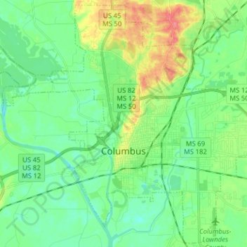
Name: Columbus topographic map, elevation, terrain.

Location: Columbus, Lowndes County, Mississippi, United States (33.45627 -88.48938 33.55787 -88.36310)

Average elevation: 180 ft

Minimum elevation: 115 ft

Maximum elevation: 331 ft

Lowndes County trails, hiking, mountain biking, running and outdoor activities

Other topographic maps

Click on a map to view its topography, its elevation and its terrain.

Billups

United States > Mississippi > Lowndes County

Average elevation: 236 ft

Penns

United States > Mississippi > Lowndes County > Penns

Average elevation: 276 ft

Cady Hills

United States > Mississippi > Lowndes County > Columbus

Average elevation: 217 ft

Gear up for your next adventure:

🛰️Handheld GPS Units - Professional satellite navigators for precise backcountry mapping
🥩Freeze-Dried Meals - Nutritious and lightweight food for remote expeditions
🪶Fire Starter Kit - Reliable fire starter for survival and camping
🧦Hiking Socks - Comfortable socks to prevent blisters on long hikes
🥾Men's Hiking Boots - Durable, waterproof footwear for rugged terrain and steep inclines

As an Amazon Associate, this site earns from qualifying purchases at no extra cost to you.