
Make a donation
Gear up for your next adventure:
As an Amazon Associate, this site earns from qualifying purchases at no extra cost to you.
El Volcán topographic map
Click on the map to display elevation.
Make a donation
Gear up for your next adventure:
As an Amazon Associate, this site earns from qualifying purchases at no extra cost to you.
El Volcán
Tras la elevación de la capilla de Nuestra Señora de la Guardia a parroquia en 1979, nació la idea de crear un Seminario Diocesano para jóvenes con vocación sacerdotal. Al principio, el seminario funcionó en la ciudad de San Luis, pero pronto se mudó a El Volcán, un lugar ideal por su clima tranquilo, la cercanía a la parroquia de Nuestra Señora de la Guardia y el contacto con la naturaleza. En 1982, seminaristas y formadores de distintas regiones del país se trasladaron al nuevo edificio.
Make a donation
Gear up for your next adventure:
As an Amazon Associate, this site earns from qualifying purchases at no extra cost to you.
About this map
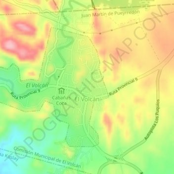
Name: El Volcán topographic map, elevation, terrain.
Average elevation: 3,219 ft
Minimum elevation: 2,923 ft
Maximum elevation: 3,478 ft
Make a donation
Gear up for your next adventure:
As an Amazon Associate, this site earns from qualifying purchases at no extra cost to you.
Other topographic maps
Click on a map to view its topography, its elevation and its terrain.
Make a donation
Gear up for your next adventure:
As an Amazon Associate, this site earns from qualifying purchases at no extra cost to you.
Quines
[cita requerida]El clima que presenta la ciudad de Quines, junto a la topografía, es continental árido con una temperatura media anual de 17 °Celsius, media invernal de 8 °Celsius y estival de 24 °Celsius. Las lluvias disminuyen de este a oeste y se dan principal mente en verano, entre los meses de…
Average elevation: 1,598 ft
Make a donation
Gear up for your next adventure:
As an Amazon Associate, this site earns from qualifying purchases at no extra cost to you.
Make a donation
Gear up for your next adventure:
As an Amazon Associate, this site earns from qualifying purchases at no extra cost to you.
Make a donation
Gear up for your next adventure:
As an Amazon Associate, this site earns from qualifying purchases at no extra cost to you.
Make a donation
Gear up for your next adventure:
As an Amazon Associate, this site earns from qualifying purchases at no extra cost to you.
Make a donation
Gear up for your next adventure:
As an Amazon Associate, this site earns from qualifying purchases at no extra cost to you.
Make a donation
Gear up for your next adventure:
As an Amazon Associate, this site earns from qualifying purchases at no extra cost to you.
Terreno Escuela Provincia de Cordoba
Argentina > San Luis > Municipio de San Luis
Average elevation: 2,441 ft
Trapiche
Argentina > San Luis > El trapiche
El pueblo se encuentra ubicado en la zona conocida como área interserrana, que comprende desde cercanías del cerro Charlone hasta las proximidades del cerro Garrapata, en el límite con la provincia de Córdoba. El relieve de esta unidad geográfica es ondulado y se extiende entre las isohietas de 500 a 600…
Average elevation: 3,543 ft
Make a donation
Gear up for your next adventure:
As an Amazon Associate, this site earns from qualifying purchases at no extra cost to you.
Make a donation
Gear up for your next adventure:
As an Amazon Associate, this site earns from qualifying purchases at no extra cost to you.
La Carolina
Estos cerros y la cueva representan un paisaje culturalmente cargado, donde la topografía, los nombres y los vestigios arqueológicos permiten reconstruir la relación espiritual y simbólica de los Michilingües con su territorio.
Average elevation: 5,610 ft
Make a donation
Gear up for your next adventure:
As an Amazon Associate, this site earns from qualifying purchases at no extra cost to you.