
Make a donation
Gear up for your next adventure:
As an Amazon Associate, this site earns from qualifying purchases at no extra cost to you.
Tilisarao topographic map
Click on the map to display elevation.
Make a donation
Gear up for your next adventure:
As an Amazon Associate, this site earns from qualifying purchases at no extra cost to you.
About this map
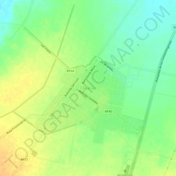
Name: Tilisarao topographic map, elevation, terrain.
Average elevation: 2,464 ft
Minimum elevation: 2,411 ft
Maximum elevation: 2,513 ft
Make a donation
Gear up for your next adventure:
As an Amazon Associate, this site earns from qualifying purchases at no extra cost to you.
Other topographic maps
Click on a map to view its topography, its elevation and its terrain.
Merlo
La Provincia de San Luis se encuentra en una zona montañosa conocida como la Región de Cuyo, y Merlo se encuentra enclavada sobre el corredor de los Comechingones, un subsistema orográfico del centro-oeste de Argentina. La altitud oscila entre los 790 y los 1200 msnm.
Average elevation: 2,884 ft
Make a donation
Gear up for your next adventure:
As an Amazon Associate, this site earns from qualifying purchases at no extra cost to you.
Make a donation
Gear up for your next adventure:
As an Amazon Associate, this site earns from qualifying purchases at no extra cost to you.
Make a donation
Gear up for your next adventure:
As an Amazon Associate, this site earns from qualifying purchases at no extra cost to you.
El Volcán
Tras la elevación de la capilla de Nuestra Señora de la Guardia a parroquia en 1979, nació la idea de crear un Seminario Diocesano para jóvenes con vocación sacerdotal. Al principio, el seminario funcionó en la ciudad de San Luis, pero pronto se mudó a El Volcán, un lugar ideal por su clima tranquilo,…
Average elevation: 3,219 ft
Make a donation
Gear up for your next adventure:
As an Amazon Associate, this site earns from qualifying purchases at no extra cost to you.
Make a donation
Gear up for your next adventure:
As an Amazon Associate, this site earns from qualifying purchases at no extra cost to you.
Terreno Escuela Provincia de Cordoba
Argentina > San Luis > Municipio de San Luis
Average elevation: 2,441 ft
Make a donation
Gear up for your next adventure:
As an Amazon Associate, this site earns from qualifying purchases at no extra cost to you.
El trapiche
Argentina > San Luis > El trapiche
El pueblo se encuentra ubicado en la zona conocida como área interserrana, que comprende desde cercanías del cerro Charlone hasta las proximidades del cerro Garrapata, en el límite con la provincia de Córdoba. El relieve de esta unidad geográfica es ondulado y se extiende entre las isohietas de 500 a 600…
Average elevation: 3,625 ft
Nueva Galia
Argentina > San Luis > Nueva Galia
Es una región llana, con médanos y pastizales, interrumpidos por pequeñas lagunas. Su altitud no supera los 320 m sobre el nivel del mar. Los suelos son arenosos con escasa retención de humedad y pocos restos orgánicos. Las capas freáticas, de agua generalmente muy salina, se encuentran antes de los 2…
Average elevation: 1,014 ft
Make a donation
Gear up for your next adventure:
As an Amazon Associate, this site earns from qualifying purchases at no extra cost to you.
El trapiche
El pueblo se encuentra ubicado en la zona conocida como área interserrana, que comprende desde cercanías del cerro Charlone hasta las proximidades del cerro Garrapata, en el límite con la provincia de Córdoba. El relieve de esta unidad geográfica es ondulado y se extiende entre las isohietas de 500 a 600…
Average elevation: 3,629 ft
Make a donation
Gear up for your next adventure:
As an Amazon Associate, this site earns from qualifying purchases at no extra cost to you.
Merlo
La Provincia de San Luis se encuentra en una zona montañosa conocida como la Región de Cuyo, y Merlo se encuentra enclavada sobre el corredor de los Comechingones, un subsistema orográfico del centro-oeste de Argentina. La altitud oscila entre los 790 y los 1200 msnm.
Average elevation: 2,884 ft
Make a donation
Gear up for your next adventure:
As an Amazon Associate, this site earns from qualifying purchases at no extra cost to you.