
Humera topographic map
Click on the map to display elevation.
Humera
Humera (Tigrinya: ሑመራ; Amharic: ሁመራ) is a town in the Kafta Humera woreda in the Tigray Region of Ethiopia. Located in the Western Zone the town has an elevation of 585 metres (1,919 ft) above sea level. The Tekezé river borders the town to the north. Humera is a very important regional agricultural center based on intensive agriculture. It is the last Ethiopian town south of the border with Eritrea and Sudan, and is considered to be a strategically important gateway to Sudan.
About this map
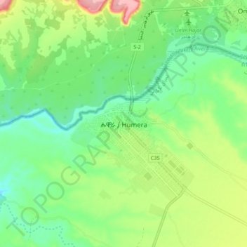
Name: Humera topographic map, elevation, terrain.
Location: Humera, Western Tigray, Tigray, Ethiopia (14.24769 36.56884 14.32769 36.64884)
Average elevation: 1,949 ft
Minimum elevation: 1,804 ft
Maximum elevation: 2,218 ft
Other topographic maps
Click on a map to view its topography, its elevation and its terrain.
Mek'elē
Mekelle (Tigrinya: መቐለ), or Mekele, is a special zone and capital of the Tigray Region of Ethiopia. Mekelle was formerly the capital of Enderta awraja in Tigray. It is located around 780 kilometres (480 mi) north of the Ethiopian capital Addis Ababa, with an elevation of 2,254 metres (7,395 ft) above sea…
Average elevation: 6,857 ft
Alamata
Alamata (Tigrinya: ኣላማጣ ) is a town in the Tigray Region of Ethiopia. Located in the Debubawi (Southern) zone of Tigray it has a latitude and longitude of 12°25′N 39°33′E / 12.417°N 39.550°E / 12.417; 39.550 and an elevation of 1,520 metres (4,990 ft) above sea level and is located…
Average elevation: 5,164 ft
Mek'elē
Mekelle (Tigrinya: መቐለ), or Mekele, is a special zone and capital of the Tigray Region of Ethiopia. Mekelle was formerly the capital of Enderta awraja in Tigray. It is located around 780 kilometres (480 mi) north of the Ethiopian capital Addis Ababa, with an elevation of 2,254 metres (7,395 ft) above sea…
Average elevation: 6,857 ft
Mek'elē
Mekelle (Tigrinya: መቐለ), or Mek'ele, is a special zone and capital of the Tigray Region of Ethiopia. Mekelle was formerly the capital of Enderta awraja in Tigray. It is located around 780 kilometres (480 mi) north of the Ethiopian capital Addis Ababa, with an elevation of 2,254 metres (7,395 ft) above…
Average elevation: 6,857 ft