
James Island topographic map
Click on the map to display elevation.
About this map
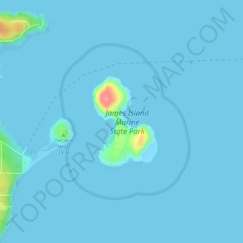
Name: James Island topographic map, elevation, terrain.
Location: James Island, San Juan County, Washington, United States (48.50765 -122.78003 48.51775 -122.76915)
Average elevation: 10 ft
Minimum elevation: -10 ft
Maximum elevation: 266 ft
San Juan County trails, hiking, mountain biking, running and outdoor activities
Other topographic maps
Click on a map to view its topography, its elevation and its terrain.
Orcas Island
United States > Washington > San Juan County > Eastsound
Orcas Island presents one of the most dramatic relief profiles in Washington’s San Juan Islands, rising abruptly from the sheltered waters of the Salish Sea to the summit of Mount Constitution, the archipelago’s highest point at about 2,409 feet (734 m). Its topography is strongly organized around steep,…
Average elevation: 194 ft
San Juan Islands National Wildlife Refuge
United States > Washington > San Juan County
Average elevation: 79 ft