Geolocate

Decatur Island topographic map

Click on the map to display elevation.

About this map

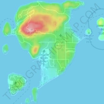
Name: Decatur Island topographic map, elevation, terrain.

Location: Decatur Island, San Juan County, Washington, United States (48.48105 -122.84004 48.52494 -122.78316)

Average elevation: 72 ft

Minimum elevation: -7 ft

Maximum elevation: 554 ft

San Juan County trails, hiking, mountain biking, running and outdoor activities

Other topographic maps

Click on a map to view its topography, its elevation and its terrain.

Eastsound

United States > Washington > San Juan County

Average elevation: 243 ft

Olga

United States > Washington > San Juan County

Average elevation: 180 ft

Ben Nevis

United States > Washington > San Juan County

Average elevation: 161 ft

Gear up for your next adventure:

🥘Titanium Cookware - Durable, featherlight pots and pans for backpacking
🧼Biodegradable Camping Soap - Eco‑friendly soap for outdoor hygiene
🛌Ultralight Sleeping Bags - Compact down bags for cold nights in the wilderness
🧥Waterproof Jacket for Hiking - Breathable and rugged rain jacket for outdoor excursions
🔦Powerful Headlamps - Ultra-bright hands-free lighting for night navigation

As an Amazon Associate, this site earns from qualifying purchases at no extra cost to you.