
Make a donation
Gear up for your next adventure:
As an Amazon Associate, this site earns from qualifying purchases at no extra cost to you.
Ostkilver topographic map
Click on the map to display elevation.
Make a donation
Gear up for your next adventure:
As an Amazon Associate, this site earns from qualifying purchases at no extra cost to you.
Ostkilver
Ostkilver liegt im Südwesten Rödinghausens auf einer Höhe zwischen 120 m ü. NN und 68 m ü. NN. Der tiefste Punkt Ostkilvers in den Elseauen ist zugleich der tiefste Punkt der Gemeinde Rödinghausen. Die Else durchfließt den Ortsteil im Süden von West nach Ost. Ostkilver hat rund 1900 Einwohner, die auf einer Fläche von 7,926 km² leben, was einer Bevölkerungsdichte von 236 Einwohnern pro km² entspricht. Ostkilver ist damit einer der Ortsteile Rödinghausens mit der geringsten Bevölkerungsdichte. In Ostkilver befindet sich das Schwimmbad der Gemeinde Rödinghausen.
Make a donation
Gear up for your next adventure:
As an Amazon Associate, this site earns from qualifying purchases at no extra cost to you.
About this map
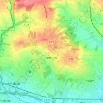
Name: Ostkilver topographic map, elevation, terrain.
Average elevation: 308 ft
Minimum elevation: 210 ft
Maximum elevation: 446 ft
Make a donation
Gear up for your next adventure:
As an Amazon Associate, this site earns from qualifying purchases at no extra cost to you.
Other topographic maps
Click on a map to view its topography, its elevation and its terrain.