Geolocate

Reserva Nacional Pampa Galeras Bárbara D’Achille topographic map

Interactive map

Click on the map to display elevation.

About this map

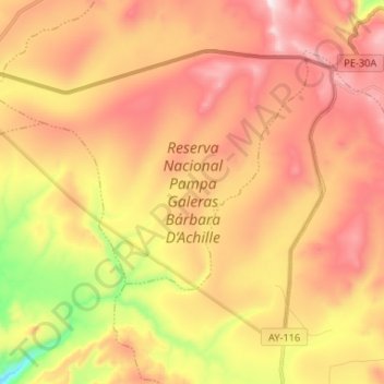
Name: Reserva Nacional Pampa Galeras Bárbara D’Achille topographic map, elevation, terrain.

Location: Reserva Nacional Pampa Galeras Bárbara D’Achille, Lucanas, Provincia de Lucanas, Ayacucho, Perú (-14.74896 -74.44934 -14.65508 -74.31792)

Average elevation: 13,058 ft

Minimum elevation: 11,696 ft

Maximum elevation: 14,081 ft

Other topographic maps

Click on a map to view its topography, its elevation and its terrain.

Provincia de Lucanas

Perú > Ayacucho > Lucanas

Provincia de Lucanas, Lucanas, Ayacucho, Perú

Average elevation: 12,054 ft

Raquina

Perú > Ayacucho > Lucanas > Raquina

Raquina, Lucanas, Provincia de Lucanas, Ayacucho, Perú

Average elevation: 11,644 ft