
Make a donation
Gear up for your next adventure:
As an Amazon Associate, this site earns from qualifying purchases at no extra cost to you.
Stony Fork topographic map
Click on the map to display elevation.
Make a donation
Gear up for your next adventure:
As an Amazon Associate, this site earns from qualifying purchases at no extra cost to you.
About this map
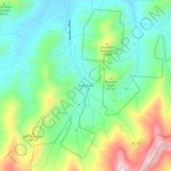
Name: Stony Fork topographic map, elevation, terrain.
Location: Stony Fork, Buncombe County, North Carolina, United States (35.44289 -82.75624 35.48289 -82.71624)
Average elevation: 2,933 ft
Minimum elevation: 2,336 ft
Maximum elevation: 4,163 ft
Buncombe County trails, hiking, mountain biking, running and outdoor activities
Make a donation
Gear up for your next adventure:
As an Amazon Associate, this site earns from qualifying purchases at no extra cost to you.
Other topographic maps
Click on a map to view its topography, its elevation and its terrain.
Pisgah National Forest
United States > North Carolina > Buncombe County
The Pisgah National Forest covers 512,758 acres (801 sq mi; 2,075 km2) of mountainous terrain in the southern Appalachian Mountains, including parts of the Blue Ridge Mountains and Great Balsam Mountains. Elevations reach over 6,000 feet (1,800 m) and include some of the highest mountains in the eastern United…
Average elevation: 2,467 ft
Royal Pines
United States > North Carolina > Buncombe County > Royal Pines
Royal Pines is bordered to the west by U.S. Route 25A and the city limits of Asheville, and to the northeast by Mills Gap Road. Brown Mountain, with an elevation of 2,996 feet (913 m), occupies the center of the CDP.
Average elevation: 2,343 ft
Beaver Lake
United States > North Carolina > Buncombe County > Asheville > Grace
Average elevation: 2,205 ft
Make a donation
Gear up for your next adventure:
As an Amazon Associate, this site earns from qualifying purchases at no extra cost to you.