
Make a donation
Gear up for your next adventure:
As an Amazon Associate, this site earns from qualifying purchases at no extra cost to you.
Bent Creek topographic map
Click on the map to display elevation.
Make a donation
Gear up for your next adventure:
As an Amazon Associate, this site earns from qualifying purchases at no extra cost to you.
About this map
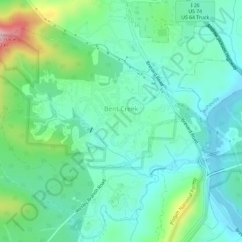
Name: Bent Creek topographic map, elevation, terrain.
Location: Bent Creek, Buncombe County, North Carolina, United States (35.49409 -82.63839 35.52044 -82.59760)
Average elevation: 2,215 ft
Minimum elevation: 1,982 ft
Maximum elevation: 2,936 ft
Buncombe County trails, hiking, mountain biking, running and outdoor activities
Make a donation
Gear up for your next adventure:
As an Amazon Associate, this site earns from qualifying purchases at no extra cost to you.
Other topographic maps
Click on a map to view its topography, its elevation and its terrain.
Make a donation
Gear up for your next adventure:
As an Amazon Associate, this site earns from qualifying purchases at no extra cost to you.
Murphy Junction
United States > North Carolina > Buncombe County > Asheville
Average elevation: 2,106 ft
Rainbow Mountain
United States > North Carolina > Buncombe County > Montreat
Average elevation: 2,858 ft
Make a donation
Gear up for your next adventure:
As an Amazon Associate, this site earns from qualifying purchases at no extra cost to you.
Make a donation
Gear up for your next adventure:
As an Amazon Associate, this site earns from qualifying purchases at no extra cost to you.
Make a donation
Gear up for your next adventure:
As an Amazon Associate, this site earns from qualifying purchases at no extra cost to you.
Make a donation
Gear up for your next adventure:
As an Amazon Associate, this site earns from qualifying purchases at no extra cost to you.
Highland Gate
United States > North Carolina > Buncombe County > Asheville
Average elevation: 2,320 ft
Make a donation
Gear up for your next adventure:
As an Amazon Associate, this site earns from qualifying purchases at no extra cost to you.
Parkway Forest
United States > North Carolina > Buncombe County > Asheville
Average elevation: 2,241 ft
Make a donation
Gear up for your next adventure:
As an Amazon Associate, this site earns from qualifying purchases at no extra cost to you.
Make a donation
Gear up for your next adventure:
As an Amazon Associate, this site earns from qualifying purchases at no extra cost to you.
Sulphur Springs
United States > North Carolina > Buncombe County > Asheville
Average elevation: 2,169 ft
Make a donation
Gear up for your next adventure:
As an Amazon Associate, this site earns from qualifying purchases at no extra cost to you.
Boswell
United States > North Carolina > Buncombe County > Asheville > Boswell
Average elevation: 2,159 ft
Sayles Village
United States > North Carolina > Buncombe County > Asheville
Average elevation: 2,129 ft
Malvern Hills
United States > North Carolina > Buncombe County > Asheville
Average elevation: 2,116 ft
Make a donation
Gear up for your next adventure:
As an Amazon Associate, this site earns from qualifying purchases at no extra cost to you.