
Make a donation
Gear up for your next adventure:
As an Amazon Associate, this site earns from qualifying purchases at no extra cost to you.
Mauna Loa topographic map
Click on the map to display elevation.
Make a donation
Gear up for your next adventure:
As an Amazon Associate, this site earns from qualifying purchases at no extra cost to you.
Mauna Loa
Mauna Loa is the largest subaerial and second largest overall volcano in the world (behind Tamu Massif), covering a land area of 5,271 km2 (2,035 sq mi) and spans a maximum width of 120 km (75 mi). Consisting of approximately 65,000 to 80,000 km3 (15,600 to 19,200 cu mi) of solid rock, it makes up more than half of the surface area of the island of Hawaiʻi. Combining the volcano's extensive submarine flanks (5,000 m (16,400 ft) to the sea floor) and 4,170 m (13,680 ft) subaerial height, Mauna Loa rises 9,170 m (30,085 ft) from base to summit, greater than the 8,848 m or 29,029 ft elevation of Mount Everest from sea level to its summit. In addition, much of the mountain is invisible even underwater: its mass depresses the crust beneath it by another 8 km (5 mi), in the shape of an inverse mountain, meaning the total height of Mauna Loa from the start of its eruptive history is about 17,170 m (56,000 ft).
Make a donation
Gear up for your next adventure:
As an Amazon Associate, this site earns from qualifying purchases at no extra cost to you.
About this map
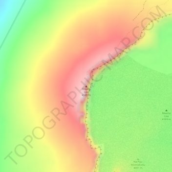
Name: Mauna Loa topographic map, elevation, terrain.
Location: Mauna Loa, Hawaiʻi County, Hawaii, United States (19.47548 -155.60575 19.47558 -155.60565)
Average elevation: 13,245 ft
Minimum elevation: 12,664 ft
Maximum elevation: 13,727 ft
Hawaiʻi County trails, hiking, mountain biking, running and outdoor activities
Make a donation
Gear up for your next adventure:
As an Amazon Associate, this site earns from qualifying purchases at no extra cost to you.
Other topographic maps
Click on a map to view its topography, its elevation and its terrain.
Hawaiian Ocean View
United States > Hawaii > Hawaiʻi County
The HOVE development consisted of 10,697 1-acre (4,000 m2) lots north of the Hawaii Belt Road in the western part of the District of Kaʻū. The terrain varies from rugged lava fields to ohiʻa trees and other vegetation. Elevation ranges from about 1,500 ft (460 m) up to the 5,000-foot (1,500 m) level.…
Average elevation: 2,372 ft
Captain Cook
United States > Hawaii > Hawaiʻi County
Most of Captain Cook lies between the 800-foot (240 m) and 2,000-foot (610 m) elevation, which makes it ideal as a coffee-growing region. It sits on the top of an ancient fault which created the famous Kealakekua Bay. Prior to the 1960s, most of Captain Cook was part of the vast Kealakekua Ranch, founded in…
Average elevation: 1,224 ft
Make a donation
Gear up for your next adventure:
As an Amazon Associate, this site earns from qualifying purchases at no extra cost to you.
Hilo
United States > Hawaii > Hawaiʻi County
Hilo has a tropical rainforest climate (Köppen Af), with substantial rainfall throughout the year. Its location on the windward coast (relative to the trade winds), makes it the fourth-wettest city in the United States, behind the southeast Alaskan cities of Whittier, Ketchikan and Yakutat, and one of the…
Average elevation: 633 ft
Volcano
United States > Hawaii > Hawaiʻi County
Owing to its altitude, ranging from below 2,800 feet (850 m) in the southeast to over 6,200 feet (1,900 m) at its uninhabited northern end, Volcano features a subtropical highland climate (Köppen Cfb), with relatively uniform temperatures and abundant rainfall throughout the year, although rainfall is…
Average elevation: 3,999 ft
Make a donation
Gear up for your next adventure:
As an Amazon Associate, this site earns from qualifying purchases at no extra cost to you.
Make a donation
Gear up for your next adventure:
As an Amazon Associate, this site earns from qualifying purchases at no extra cost to you.
Waimea/Kamuela
United States > Hawaii > Hawaiʻi County
Waimea is located in the northern part of the island of Hawaii at 20°1′26″N 155°38′50″W / 20.02389°N 155.64722°W / 20.02389; -155.64722 (20.023926, -155.647357), at an elevation of 2,676 feet (816 m) above sea level. It sits at the southern foot of Kohala, the oldest volcano on the island,…
Average elevation: 2,874 ft
Make a donation
Gear up for your next adventure:
As an Amazon Associate, this site earns from qualifying purchases at no extra cost to you.
Hawaiian Ocean View
United States > Hawaii > Hawaiʻi County
The HOVE development consisted of 10,697 1-acre (4,000 m2) lots north of the Hawaii Belt Road in the western part of the District of Kaʻū. The terrain varies from rugged lava fields to ohiʻa trees and other vegetation. Elevation ranges from about 1,500 ft (460 m) up to the 5,000-foot (1,500 m) level.…
Average elevation: 2,372 ft
Hilo
United States > Hawaii > Hawaiʻi County
Hilo has a tropical rainforest climate (Köppen Af), with substantial rainfall throughout the year. Its location on the windward coast (relative to the trade winds), makes it the fourth-wettest city in the United States, behind the southeast Alaskan cities of Whittier, Ketchikan and Yakutat, and one of the…
Average elevation: 633 ft
Make a donation
Gear up for your next adventure:
As an Amazon Associate, this site earns from qualifying purchases at no extra cost to you.
Volcano
United States > Hawaii > Hawaiʻi County
Its altitude ranges from below 2,800 feet (850 m) in the southeast to over 6,200 feet (1,900 m) at its uninhabited northern end. Due to this, Volcano features a subtropical highland climate (Köppen Cfb), with relatively uniform temperatures and abundant rainfall throughout the year, although rainfall is…
Average elevation: 3,999 ft
Captain Cook
United States > Hawaii > Hawaiʻi County
Most of Captain Cook lies between the 800-foot (240 m) and 2,000-foot (610 m) elevation, which makes it ideal as a coffee-growing region. It sits on the top of an ancient fault which created the famous Kealakekua Bay. Prior to the 1960s, most of Captain Cook was part of the vast Kealakekua Ranch, founded in…
Average elevation: 1,394 ft
Make a donation
Gear up for your next adventure:
As an Amazon Associate, this site earns from qualifying purchases at no extra cost to you.
Make a donation
Gear up for your next adventure:
As an Amazon Associate, this site earns from qualifying purchases at no extra cost to you.
Hilo
United States > Hawaii > Hawaiʻi County
Hilo has a tropical rainforest climate (Köppen: Af), with substantial rainfall throughout the year. Its location on the windward coast (relative to the trade winds), makes it the fourth-wettest city in the United States, behind the southeast Alaskan cities of Whittier, Ketchikan and Yakutat, and one of the…
Average elevation: 633 ft
Waimea/Kamuela
United States > Hawaii > Hawaiʻi County
Waimea is located in the northern part of the island of Hawaii at an elevation of 2,676 feet (816 m) above sea level. It sits at the southern foot of Kohala, the oldest volcano on the island, and it is near the northwestern base of Mauna Kea, the highest volcano.
Average elevation: 2,943 ft
Make a donation
Gear up for your next adventure:
As an Amazon Associate, this site earns from qualifying purchases at no extra cost to you.
Volcano
United States > Hawaii > Hawaiʻi County
Its altitude ranges from below 2,800 feet (850 m) in the southeast to over 6,200 feet (1,900 m) at its uninhabited northern end. Due to this, Volcano features a subtropical highland climate (Köppen Cfb), with relatively uniform temperatures and abundant rainfall throughout the year, although rainfall is…
Average elevation: 3,999 ft
Hilo
United States > Hawaii > Hawaiʻi County
Hilo has a tropical rainforest climate (Köppen: Af), with substantial rainfall throughout the year. Its location on the windward coast (relative to the trade winds), makes it the fourth-wettest city in the United States, behind the southeast Alaskan cities of Whittier, Ketchikan and Yakutat, and one of the…
Average elevation: 846 ft
Waimea/Kamuela
United States > Hawaii > Hawaiʻi County
Waimea is located in the northern part of the island of Hawaii at an elevation of 2,676 feet (816 m) above sea level. It sits at the southern foot of Kohala, the oldest volcano on the island, and it is near the northwestern base of Mauna Kea, the highest volcano.
Average elevation: 2,874 ft
Make a donation
Gear up for your next adventure:
As an Amazon Associate, this site earns from qualifying purchases at no extra cost to you.
Hilo
United States > Hawaii > Hawaiʻi County
Hilo has a tropical rainforest climate (Köppen: Af), with substantial rainfall throughout the year. Its location on the windward coast (relative to the trade winds), makes it the fourth-wettest city in the United States, behind the southeast Alaskan cities of Whittier, Ketchikan and Yakutat, and one of the…
Average elevation: 633 ft
Volcano
United States > Hawaii > Hawaiʻi County
Its altitude ranges from below 2,800 feet (850 m) in the southeast to over 6,200 feet (1,900 m) at its uninhabited northern end. Due to this, Volcano features a subtropical highland climate (Köppen Cfb), with relatively uniform temperatures and abundant rainfall throughout the year, although rainfall is…
Average elevation: 3,645 ft
Volcano
United States > Hawaii > Hawaiʻi County
Its altitude ranges from below 2,800 feet (850 m) in the southeast to over 6,200 feet (1,900 m) at its uninhabited northern end. Due to this, Volcano features a subtropical highland climate (Köppen Cfb), with relatively uniform temperatures and abundant rainfall throughout the year, although rainfall is…
Average elevation: 3,999 ft
Make a donation
Gear up for your next adventure:
As an Amazon Associate, this site earns from qualifying purchases at no extra cost to you.
Waimea/Kamuela
United States > Hawaii > Hawaiʻi County
Waimea is located in the northern part of the island of Hawaii at 20°1′26″N 155°38′50″W / 20.02389°N 155.64722°W / 20.02389; -155.64722 (20.023926, -155.647357), at an elevation of 2,676 feet (816 m) above sea level. It sits at the southern foot of Kohala, the oldest volcano on the island,…
Average elevation: 2,874 ft
Make a donation
Gear up for your next adventure:
As an Amazon Associate, this site earns from qualifying purchases at no extra cost to you.