
Pertusa topographic map
Click on the map to display elevation.
About this map
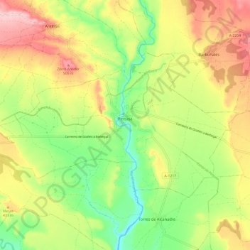
Name: Pertusa topographic map, elevation, terrain.
Average elevation: 1,378 ft
Minimum elevation: 1,076 ft
Maximum elevation: 1,729 ft
Other topographic maps
Click on a map to view its topography, its elevation and its terrain.
Santa Eulalia la Mayor
Spain > Aragon > Hoya de Huesca / Plana de Uesca > Loporzano
Average elevation: 2,592 ft
Santa María de la Peña
Spain > Aragon > Hoya de Huesca / Plana de Uesca > Las Peñas de Riglos
Average elevation: 2,238 ft
Riglos
Spain > Aragon > Hoya de Huesca / Plana de Uesca > Las Peñas de Riglos
Average elevation: 2,382 ft
Peña Foratata
Spain > Aragon > Hoya de Huesca / Plana de Uesca > Loporzano
Average elevation: 3,474 ft
Marcuello
Spain > Aragon > Hoya de Huesca / Plana de Uesca > Loarre > Linás de Marcuello
Average elevation: 2,831 ft
Vitales
Spain > Aragon > Hoya de Huesca / Plana de Uesca > Monflorite-Lascasas
Average elevation: 1,614 ft