
Make a donation
Gear up for your next adventure:
As an Amazon Associate, this site earns from qualifying purchases at no extra cost to you.
Louisville topographic map
Click on the map to display elevation.
Make a donation
Gear up for your next adventure:
As an Amazon Associate, this site earns from qualifying purchases at no extra cost to you.
About this map
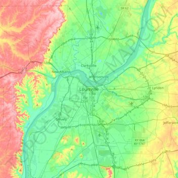
Name: Louisville topographic map, elevation, terrain.
Location: Louisville, Jefferson County, Kentucky, 40202, United States (38.09424 -85.91941 38.41424 -85.59941)
Average elevation: 591 ft
Minimum elevation: 371 ft
Maximum elevation: 1,014 ft
Jefferson County trails, hiking, mountain biking, running and outdoor activities
Make a donation
Gear up for your next adventure:
As an Amazon Associate, this site earns from qualifying purchases at no extra cost to you.
Other topographic maps
Click on a map to view its topography, its elevation and its terrain.
Louisville
United States > Kentucky > Jefferson County
Louisville features a diverse topography shaped by the Ohio River and surrounding landscape. The city lies at an elevation of approximately 466 feet (142 meters) and is characterized by rolling hills and valleys, with the highest point in the county reaching about 902 feet (275 meters) at South Park Hill in…
Average elevation: 617 ft
Iroquois Park
United States > Kentucky > Jefferson County > Louisville > Parkwood
Average elevation: 548 ft
Make a donation
Gear up for your next adventure:
As an Amazon Associate, this site earns from qualifying purchases at no extra cost to you.
E.P. "Tom" Sawyer State Park
United States > Kentucky > Jefferson County > Louisville > Lakeland
Average elevation: 686 ft
Make a donation
Gear up for your next adventure:
As an Amazon Associate, this site earns from qualifying purchases at no extra cost to you.
Mockingbird Valley
United States > Kentucky > Jefferson County
Numerous wild animals reside in Mockingbird Valley, including white-tailed deer, coyote, red fox, groundhog, opossum, raccoon and the occasional mink. Birding enthusiasts have also recorded sightings of wild turkey, blue heron, turkey vulture, red tail hawk, pileated woodpecker, and the great horned owl. Due…
Average elevation: 522 ft
Louisville
United States > Kentucky > Jefferson County
Throughout January 1937, 19.17 inches (48.7 cm) of rain fell in Louisville, and by January 27, the Ohio River crested at a record 57.15 feet (17.42 m), almost 30 feet (9.1 m) above flood stage. These events triggered the "Great Flood of 1937", which lasted into early February. The flood submerged 60–70…
Average elevation: 617 ft
Make a donation
Gear up for your next adventure:
As an Amazon Associate, this site earns from qualifying purchases at no extra cost to you.
Louisville
United States > Kentucky > Jefferson County
Throughout January 1937, 19.17 inches (48.7 cm) of rain fell in Louisville, and by January 27, the Ohio River crested at a record 57.15 feet (17.42 m), almost 30 feet (9.1 m) above flood stage. These events triggered the "Great Flood of 1937", which lasted into early February. The flood submerged 60–70…
Average elevation: 617 ft
Make a donation
Gear up for your next adventure:
As an Amazon Associate, this site earns from qualifying purchases at no extra cost to you.
Louisville
United States > Kentucky > Jefferson County
Throughout January 1937, 19.17 inches (48.7 cm) of rain fell in Louisville, and by January 27, the Ohio River crested at a record 57.15 feet (17.42 m), almost 30 feet (9.1 m) above flood stage. These events triggered the "Great Flood of 1937", which lasted into early February. The flood submerged 60–70…
Average elevation: 617 ft
Make a donation
Gear up for your next adventure:
As an Amazon Associate, this site earns from qualifying purchases at no extra cost to you.
Make a donation
Gear up for your next adventure:
As an Amazon Associate, this site earns from qualifying purchases at no extra cost to you.
Louisville
United States > Kentucky > Jefferson County
Throughout January 1937, 19.17 inches (48.7 cm) of rain fell in Louisville, and by January 27, the Ohio River crested at a record 57.15 feet (17.42 m), almost 30 feet (9.1 m) above flood stage. These events triggered the "Great Flood of 1937", which lasted into early February. The flood submerged 60–70…
Average elevation: 617 ft
E.P. "Tom" Sawyer State Park
United States > Kentucky > Jefferson County > Louisville > Lakeland
Average elevation: 686 ft
Louisville
United States > Kentucky > Jefferson County
Throughout January 1937, 19.17 inches (48.7 cm) of rain fell in Louisville, and by January 27, the Ohio River crested at a record 57.15 feet (17.42 m), almost 30 feet (9.1 m) above flood stage. These events triggered the "Great Flood of 1937", which lasted into early February. The flood submerged 60–70…
Average elevation: 617 ft
Make a donation
Gear up for your next adventure:
As an Amazon Associate, this site earns from qualifying purchases at no extra cost to you.
Make a donation
Gear up for your next adventure:
As an Amazon Associate, this site earns from qualifying purchases at no extra cost to you.