
Make a donation
Gear up for your next adventure:
As an Amazon Associate, this site earns from qualifying purchases at no extra cost to you.
Louisville topographic map
Click on the map to display elevation.
Make a donation
Gear up for your next adventure:
As an Amazon Associate, this site earns from qualifying purchases at no extra cost to you.
Louisville
Louisville features a diverse topography shaped by the Ohio River and surrounding landscape. The city lies at an elevation of approximately 466 feet (142 meters) and is characterized by rolling hills and valleys, with the highest point in the county reaching about 902 feet (275 meters) at South Park Hill in the southern region. The terrain is predominantly land, with about 380 square miles (980 square kilometers) of land area, interspersed with waterways, including the Ohio River, which forms the northern boundary of the county and serves as a vital transportation route. The area is also marked by notable features such as the Falls of the Ohio, which historically posed a significant barrier to river navigation, contributing to Louisville's early development as a strategic port. This combination of riverine and elevated landscapes provides a unique backdrop for the city, influencing its climate and development patterns.
Make a donation
Gear up for your next adventure:
As an Amazon Associate, this site earns from qualifying purchases at no extra cost to you.
About this map
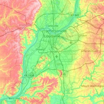
Name: Louisville topographic map, elevation, terrain.
Location: Louisville, Jefferson County, Kentucky, United States (37.99710 -85.94706 38.38014 -85.40510)
Average elevation: 617 ft
Minimum elevation: 374 ft
Maximum elevation: 1,004 ft
Jefferson County trails, hiking, mountain biking, running and outdoor activities
Make a donation
Gear up for your next adventure:
As an Amazon Associate, this site earns from qualifying purchases at no extra cost to you.
Other topographic maps
Click on a map to view its topography, its elevation and its terrain.
Make a donation
Gear up for your next adventure:
As an Amazon Associate, this site earns from qualifying purchases at no extra cost to you.
Pleasure Ridge Park
United States > Kentucky > Jefferson County > Louisville
Average elevation: 466 ft
Make a donation
Gear up for your next adventure:
As an Amazon Associate, this site earns from qualifying purchases at no extra cost to you.
Iroquois Park
United States > Kentucky > Jefferson County > Louisville > Parkwood
Average elevation: 548 ft
Make a donation
Gear up for your next adventure:
As an Amazon Associate, this site earns from qualifying purchases at no extra cost to you.
Make a donation
Gear up for your next adventure:
As an Amazon Associate, this site earns from qualifying purchases at no extra cost to you.
Make a donation
Gear up for your next adventure:
As an Amazon Associate, this site earns from qualifying purchases at no extra cost to you.
E.P. "Tom" Sawyer State Park
United States > Kentucky > Jefferson County > Louisville > Lakeland
Average elevation: 686 ft
Make a donation
Gear up for your next adventure:
As an Amazon Associate, this site earns from qualifying purchases at no extra cost to you.
Indian Hills Cherokee Section
United States > Kentucky > Jefferson County > Indian Hills
Average elevation: 551 ft
Make a donation
Gear up for your next adventure:
As an Amazon Associate, this site earns from qualifying purchases at no extra cost to you.
Make a donation
Gear up for your next adventure:
As an Amazon Associate, this site earns from qualifying purchases at no extra cost to you.