Geolocate

Santa Cruz topographic map

Click on the map to display elevation.

About this map

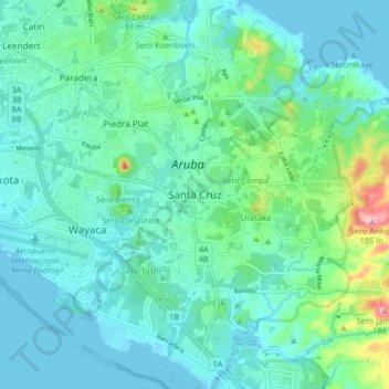
Name: Santa Cruz topographic map, elevation, terrain.

Location: Santa Cruz, Aruba, Netherlands (12.47136 -70.02043 12.55136 -69.94043)

Average elevation: 115 ft

Minimum elevation: -7 ft

Maximum elevation: 623 ft

Other topographic maps

Click on a map to view its topography, its elevation and its terrain.

Aruba

Aruba

Average elevation: 36 ft

Gear up for your next adventure:

🕶️GPS Smartphone Mount - Secure mount for phone navigation
🧤Hiking Gloves - Protective gloves for rugged trails
🧴Hand Sanitizer - Keep hands clean while hiking
🧢Sun Protection Hats - Wide-brimmed and UPF-rated hats for high-altitude sun safety
📦Gear Storage Bags - Organize and protect outdoor equipment

As an Amazon Associate, this site earns from qualifying purchases at no extra cost to you.