Geolocate

Aruba topographic map

Click on the map to display elevation.

About this map

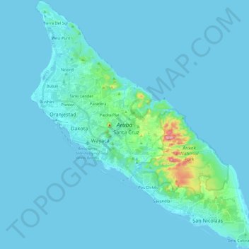
Name: Aruba topographic map, elevation, terrain.

Location: Aruba, Netherlands (12.41183 -70.06384 12.62337 -69.86546)

Average elevation: 36 ft

Minimum elevation: -7 ft

Maximum elevation: 620 ft

Other topographic maps

Click on a map to view its topography, its elevation and its terrain.

Santa Cruz

Aruba

Average elevation: 115 ft

Catiri

Aruba

Average elevation: 98 ft

Tierra Del Sol

Aruba

Average elevation: 16 ft

Gear up for your next adventure:

📷Action Cameras - Rugged cameras to document your journeys across rugged terrain
🪶Trail Camera - Capture wildlife on your hikes
🧴Hand Sanitizer - Keep hands clean while hiking
🦺Reflective Outdoor Gear - Safety gear for low‑light conditions
🗺️NatGeo Topo Maps - High-quality waterproof printed topographic maps of US Parks

As an Amazon Associate, this site earns from qualifying purchases at no extra cost to you.