
Make a donation
Gear up for your next adventure:
As an Amazon Associate, this site earns from qualifying purchases at no extra cost to you.
Anapa topographic map
Click on the map to display elevation.
Make a donation
Gear up for your next adventure:
As an Amazon Associate, this site earns from qualifying purchases at no extra cost to you.
Anapa
Anapa has a humid subtropical climate (Köppen climate classification Cfa) with mediterranean (Csa) influences at the lower elevations. Compared to cities further south along the coast like Novorossiysk and Sochi, Anapa receives considerably less rainfall but has somewhat colder winters.
Make a donation
Gear up for your next adventure:
As an Amazon Associate, this site earns from qualifying purchases at no extra cost to you.
About this map
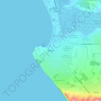
Name: Anapa topographic map, elevation, terrain.
Average elevation: 52 ft
Minimum elevation: -10 ft
Maximum elevation: 617 ft
Make a donation
Gear up for your next adventure:
As an Amazon Associate, this site earns from qualifying purchases at no extra cost to you.