Geolocate

Mabalor topographic map

Click on the map to display elevation.

About this map

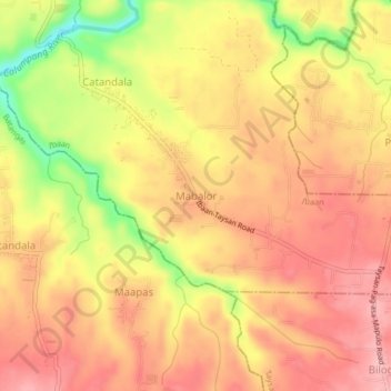
Name: Mabalor topographic map, elevation, terrain.

Location: Mabalor, Ibaan, Batangas, Calabarzon, 4228, Philippines (13.75807 121.13833 13.79807 121.17833)

Average elevation: 351 ft

Minimum elevation: 66 ft

Maximum elevation: 502 ft

Other topographic maps

Click on a map to view its topography, its elevation and its terrain.

Calumpang River

Philippines > Batangas > Ibaan > Catandala

Average elevation: 305 ft

Calumpang River

Philippines > Batangas > Ibaan

Average elevation: 325 ft

Coliat

Philippines > Batangas > Ibaan

Average elevation: 371 ft

Talaibon

Philippines > Batangas > Ibaan

Average elevation: 466 ft

Calumpang River

Philippines > Batangas > Ibaan > Balanga

Average elevation: 276 ft

Pangao

Philippines > Batangas > Ibaan

Average elevation: 427 ft

Taysan River

Philippines > Batangas > Ibaan > Salaban Ⅱ

Average elevation: 456 ft

Palindan

Philippines > Batangas > Ibaan

Average elevation: 440 ft

Balanga

Philippines > Batangas > Ibaan

Average elevation: 305 ft

Calumpang River

Philippines > Batangas > Ibaan > Balanga

Average elevation: 276 ft

Pangao

Philippines > Batangas > Ibaan

Average elevation: 427 ft

Gear up for your next adventure:

🦶Carbon Trekking Poles - Reduce knee impact on steep descents with ultra-light poles
🪶Camping Sleeping Pad - Comfortable sleeping pad for backpacking
📻Weather Alert Radios - Stay informed of storm risks while off-the-grid
⛑️Personal Locator Beacon - Safety beacon for emergencies
🌎3D Topographic Globes - Raised relief globes for a tactile understanding of geography

As an Amazon Associate, this site earns from qualifying purchases at no extra cost to you.