Geolocate

Fox Lake topographic map

Click on the map to display elevation.

About this map

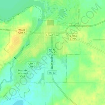
Name: Fox Lake topographic map, elevation, terrain.

Location: Fox Lake, Dodge County, Wisconsin, 53933, United States (43.54882 -88.93286 43.57318 -88.89670)

Average elevation: 906 ft

Minimum elevation: 866 ft

Maximum elevation: 945 ft

Dodge County trails, hiking, mountain biking, running and outdoor activities

Other topographic maps

Click on a map to view its topography, its elevation and its terrain.

Ashippun

United States > Wisconsin > Dodge County

Average elevation: 892 ft

Burnett

United States > Wisconsin > Dodge County

Average elevation: 892 ft

Rubicon

United States > Wisconsin > Dodge County

Average elevation: 1,040 ft

Lebanon

United States > Wisconsin > Dodge County

Average elevation: 912 ft

Gear up for your next adventure:

📌Outdoor GPS Map App - Apps and devices for digital topographic navigation
🚗GPS Dash Cams - Record your scenic drives through mountain passes and canyons
📦Dry Bags Set - Waterproof storage for electronics and clothes
🏕️Tent Footprint - Protect your tent base from wear
🧥Men's Rain Shells - Premium waterproof and breathable jackets for mountain weather

As an Amazon Associate, this site earns from qualifying purchases at no extra cost to you.