Geolocate

Waltham topographic map

Click on the map to display elevation.

About this map

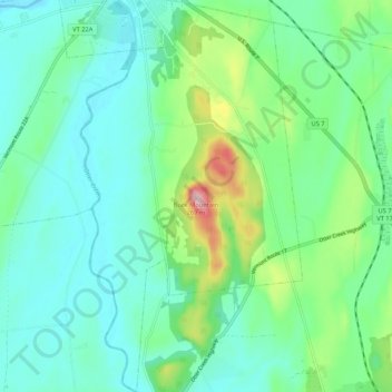
Name: Waltham topographic map, elevation, terrain.

Location: Waltham, Addison County, Vermont, United States (44.08823 -73.26451 44.16409 -73.20476)

Average elevation: 282 ft

Minimum elevation: 102 ft

Maximum elevation: 873 ft

Addison County trails, hiking, mountain biking, running and outdoor activities

Other topographic maps

Click on a map to view its topography, its elevation and its terrain.

South Mountain

United States > Vermont > Addison County > Bristol

Average elevation: 1,939 ft

Richville

United States > Vermont > Addison County > Shoreham

Average elevation: 322 ft

South Lincoln

United States > Vermont > Addison County > Lincoln

Average elevation: 1,457 ft

Bread Loaf

United States > Vermont > Addison County > Ripton

Average elevation: 1,631 ft

Chimney Point

United States > Vermont > Addison County > Addison

Average elevation: 105 ft

Bristol

United States > Vermont > Addison County > Bristol > Bristol

Average elevation: 876 ft

Gear up for your next adventure:

GPS Sports Watch - GPS watch for running, hiking and training
🧭Hiking Compass - Precision compass for reliable navigation in the wilderness
🔥Fast-Boil Camping Stoves - Efficient cooking systems for quick trail meals
🔥Camping Stove - Portable stove for camping and backcountry cooking
🧣Hiking Neck Gaiter - Multi‑use neck protection for outdoor weather

As an Amazon Associate, this site earns from qualifying purchases at no extra cost to you.