Geolocate

Addison topographic map

Click on the map to display elevation.

About this map

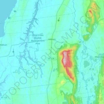
Name: Addison topographic map, elevation, terrain.

Location: Addison, Addison County, Vermont, United States (44.02111 -73.43774 44.12378 -73.24959)

Average elevation: 220 ft

Minimum elevation: 79 ft

Maximum elevation: 1,263 ft

Addison County trails, hiking, mountain biking, running and outdoor activities

Other topographic maps

Click on a map to view its topography, its elevation and its terrain.

South Mountain

United States > Vermont > Addison County > Bristol

Average elevation: 1,939 ft

Richville

United States > Vermont > Addison County > Shoreham

Average elevation: 322 ft

South Lincoln

United States > Vermont > Addison County > Lincoln

Average elevation: 1,457 ft

Bread Loaf

United States > Vermont > Addison County > Ripton

Average elevation: 1,631 ft

Chimney Point

United States > Vermont > Addison County > Addison

Average elevation: 105 ft

Bristol

United States > Vermont > Addison County > Bristol > Bristol

Average elevation: 876 ft

Gear up for your next adventure:

🪶Camp Gear Gift Set - Perfect gift bundle for outdoor fans
🗺️NatGeo Topo Maps - High-quality waterproof printed topographic maps of US Parks
🏕️Tent Footprint - Protect your tent base from wear
🪶Fire Starter Kit - Reliable fire starter for survival and camping
📷Action Camera - Capture your outdoor adventures in HD

As an Amazon Associate, this site earns from qualifying purchases at no extra cost to you.