Geolocate

Allouez topographic map

Click on the map to display elevation.

About this map

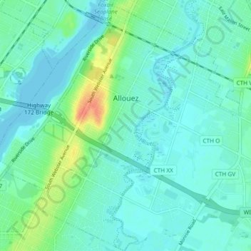
Name: Allouez topographic map, elevation, terrain.

Location: Allouez, Brown County, Wisconsin, 54301, United States (44.44508 -88.05560 44.49816 -87.99714)

Average elevation: 607 ft

Minimum elevation: 577 ft

Maximum elevation: 705 ft

Brown County trails, hiking, mountain biking, running and outdoor activities

Other topographic maps

Click on a map to view its topography, its elevation and its terrain.

Greenleaf

United States > Wisconsin > Brown County

Average elevation: 741 ft

Anston

United States > Wisconsin > Brown County

Average elevation: 738 ft

Champion

United States > Wisconsin > Brown County

Average elevation: 771 ft

New Franken

United States > Wisconsin > Brown County

Average elevation: 801 ft

Holland

United States > Wisconsin > Brown County

Average elevation: 771 ft

Bellevue

United States > Wisconsin > Brown County > Bellevue > Bellevue

Average elevation: 692 ft

Gear up for your next adventure:

🧯Portable Fire Pit - Compact fire pit for camping spots
📡GPS Antenna Upgrade - Enhance GPS reception in remote terrain
🪓Survival Multi‑Tool - Versatile tool for camp and trail tasks
🧢Sun Protection Hats - Wide-brimmed and UPF-rated hats for high-altitude sun safety
📚Navigation Handbooks - Master the art of reading topographic maps and using a compass

As an Amazon Associate, this site earns from qualifying purchases at no extra cost to you.