Geolocate

7th district topographic map

Click on the map to display elevation.

About this map

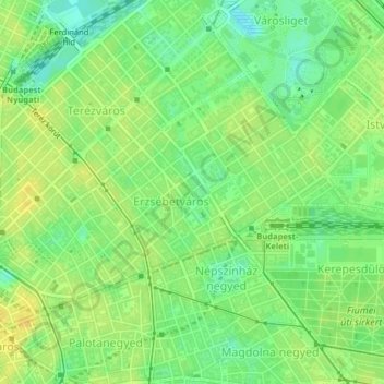
Name: 7th district topographic map, elevation, terrain.

Location: 7th district, Budapest, Central Hungary, Hungary (47.49431 19.05516 47.51122 19.09114)

Average elevation: 377 ft

Minimum elevation: 335 ft

Maximum elevation: 410 ft

Other topographic maps

Click on a map to view its topography, its elevation and its terrain.

Háros-sziget

Hungary > Budapest

Average elevation: 522 ft

Danube

Hungary > Budapest

Average elevation: 410 ft

Gear up for your next adventure:

🗻Climbing Gear Basics - Essential gear for beginner climbers
🌧️Backpack Rain Cover - Keep gear dry in wet weather
🥇GPS Hiking Watch - Multi‑sport GPS watch with navigation and trail tracking
🔭Telescopic Hiking Pole - Adjustable pole for hiking stability
🔋Solar Power Banks - Keep your GPS and phone charged in remote wilderness areas

As an Amazon Associate, this site earns from qualifying purchases at no extra cost to you.