Geolocate

Bethlehem topographic map

Click on the map to display elevation.

About this map

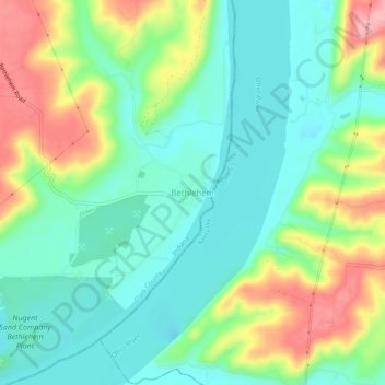
Name: Bethlehem topographic map, elevation, terrain.

Location: Bethlehem, Clark County, Indiana, 47104, United States (38.51923 -85.44051 38.55923 -85.40051)

Average elevation: 558 ft

Minimum elevation: 407 ft

Maximum elevation: 846 ft

Clark County trails, hiking, mountain biking, running and outdoor activities

Other topographic maps

Click on a map to view its topography, its elevation and its terrain.

Oak Park

United States > Indiana > Clark County

Average elevation: 459 ft

New Washington

United States > Indiana > Clark County

Average elevation: 702 ft

Utica

United States > Indiana > Clark County

Average elevation: 466 ft

Memphis

United States > Indiana > Clark County

Average elevation: 502 ft

Gear up for your next adventure:

🕶️Glacier Sunglasses - Side shields to protect eyes from high-altitude snow glare
🪶LED Camping Lantern - Bright lantern for camp lighting
👓Polarized Sunglasses - Outdoor sunglasses for glare reduction
🛠️Outdoor Gear Repair Kit - Essential tools to fix gear on the trail
🎒Day Hiking Backpack - Lightweight backpack perfect for day trips and outdoor adventures

As an Amazon Associate, this site earns from qualifying purchases at no extra cost to you.