Geolocate

Utica topographic map

Click on the map to display elevation.

About this map

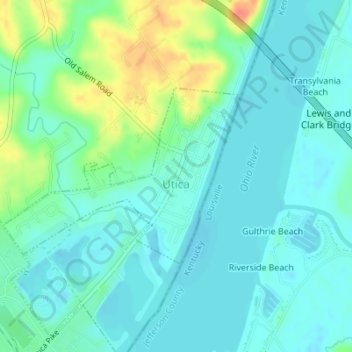
Name: Utica topographic map, elevation, terrain.

Location: Utica, Clark County, Indiana, United States (38.32752 -85.67050 38.34105 -85.64719)

Average elevation: 466 ft

Minimum elevation: 423 ft

Maximum elevation: 581 ft

Clark County trails, hiking, mountain biking, running and outdoor activities

Other topographic maps

Click on a map to view its topography, its elevation and its terrain.

Underwood

United States > Indiana > Clark County

Average elevation: 636 ft

Starlight

United States > Indiana > Clark County

Average elevation: 837 ft

Nabb

United States > Indiana > Clark County

Average elevation: 696 ft

Marysville

United States > Indiana > Clark County

Average elevation: 692 ft

Otisco

United States > Indiana > Clark County

Average elevation: 650 ft

Rolling Hills

United States > Indiana > Clark County

Average elevation: 643 ft

Bethlehem

United States > Indiana > Clark County

Average elevation: 558 ft

Speed

United States > Indiana > Clark County > Speed

Average elevation: 482 ft

Owen

United States > Indiana > Clark County

Average elevation: 597 ft

Port Fulton

United States > Indiana > Clark County > Jeffersonville

Average elevation: 459 ft

Gear up for your next adventure:

🔥Fast-Boil Camping Stoves - Efficient cooking systems for quick trail meals
📌Outdoor GPS Map App - Apps and devices for digital topographic navigation
🛡️Insect Repellent - Protection against bugs during outdoor activities
📚USA Hiking Guide Books - Top trail guides and map books
🧭Orienteering Set - Complete compass and map reading kit

As an Amazon Associate, this site earns from qualifying purchases at no extra cost to you.