Geolocate

Passaic topographic map

Click on the map to display elevation.

About this map

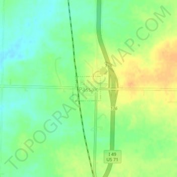
Name: Passaic topographic map, elevation, terrain.

Location: Passaic, Bates County, Missouri, United States (38.32020 -94.35136 38.32394 -94.34597)

Average elevation: 866 ft

Minimum elevation: 817 ft

Maximum elevation: 922 ft

Bates County trails, hiking, mountain biking, running and outdoor activities

Other topographic maps

Click on a map to view its topography, its elevation and its terrain.

Johnstown

United States > Missouri > Bates County

Average elevation: 823 ft

Hudson

United States > Missouri > Bates County

Average elevation: 873 ft

Gear up for your next adventure:

📦Gear Storage Bags - Organize and protect outdoor equipment
🛠️Backpacking Tool Kit - Essential toolkit for outdoor repairs
🔥Plasma Lighters - Windproof lighters that work in any weather condition
🧯Emergency Survival Kit - All‑in‑one survival essentials for the backcountry
🪶Fire Starter Kit - Reliable fire starter for survival and camping

As an Amazon Associate, this site earns from qualifying purchases at no extra cost to you.