Geolocate

Overlea topographic map

Click on the map to display elevation.

About this map

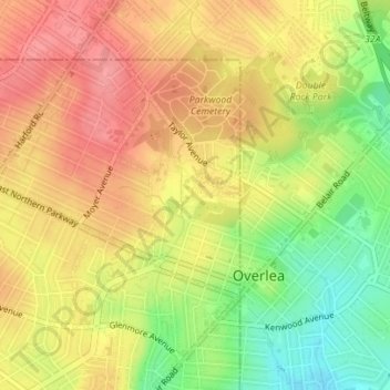
Name: Overlea topographic map, elevation, terrain.

Location: Overlea, Baltimore, Maryland, United States (39.35554 -76.54095 39.36958 -76.52968)

Average elevation: 262 ft

Minimum elevation: 102 ft

Maximum elevation: 374 ft

Maryland trails, hiking, mountain biking, running and outdoor activities

Other topographic maps

Click on a map to view its topography, its elevation and its terrain.

Ravens' Walk

United States > Maryland > Baltimore

Average elevation: 49 ft

Riverside Park

United States > Maryland > Baltimore

Average elevation: 16 ft

Gear up for your next adventure:

🛏️Cold Weather Sleeping Bag - Warm sleeping bag for cold conditions
🧭Map Reading Tools - Tools and kits for map navigation
🪶Survival Guide Book - Expert advice for emergency preparedness
🔦Compact Flashlight - Reliable flashlight for emergencies
🗺️Topographic Maps - Detailed topo maps for hiking, exploring and outdoor navigation

As an Amazon Associate, this site earns from qualifying purchases at no extra cost to you.