Geolocate

Ravens' Walk topographic map

Click on the map to display elevation.

About this map

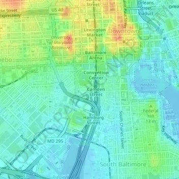
Name: Ravens' Walk topographic map, elevation, terrain.

Location: Ravens' Walk, Sowebo, Baltimore, Maryland, United States (39.28186 -76.62187 39.28283 -76.62031)

Average elevation: 49 ft

Minimum elevation: -36 ft

Maximum elevation: 161 ft

Maryland trails, hiking, mountain biking, running and outdoor activities

Other topographic maps

Click on a map to view its topography, its elevation and its terrain.

Patterson Park

United States > Maryland > Baltimore

Average elevation: 56 ft

Reisterstown Station

United States > Maryland > Baltimore

Average elevation: 443 ft

Overlea

United States > Maryland > Baltimore

Average elevation: 262 ft

Callaway-Garrison

United States > Maryland > Baltimore

Average elevation: 407 ft

Baltimore Highlands

United States > Maryland > Baltimore

Average elevation: 72 ft

Roland Park

United States > Maryland > Baltimore

Average elevation: 312 ft

Mount Vernon

United States > Maryland > Baltimore

Average elevation: 95 ft

Mount Washington

United States > Maryland > Baltimore

Average elevation: 358 ft

Downtown

United States > Maryland > Baltimore

Average elevation: 66 ft

Broadway East

United States > Maryland > Baltimore

Average elevation: 118 ft

Harwood

United States > Maryland > Baltimore

Average elevation: 177 ft

Belair-Edison

United States > Maryland > Baltimore

Average elevation: 135 ft

Four by Four

United States > Maryland > Baltimore

Average elevation: 135 ft

Gear up for your next adventure:

🗻Climbing Gear Basics - Essential gear for beginner climbers
📚USA Hiking Guide Books - Top trail guides and map books
👟Trail Running Shoes - Lightweight shoes for trail runners
🏕️Family Camping Gear - Essentials for group camping trips
🧺Microfiber Travel Towels - Compact and fast-drying towels for trail use

As an Amazon Associate, this site earns from qualifying purchases at no extra cost to you.