Geolocate

Imogene topographic map

Click on the map to display elevation.

About this map

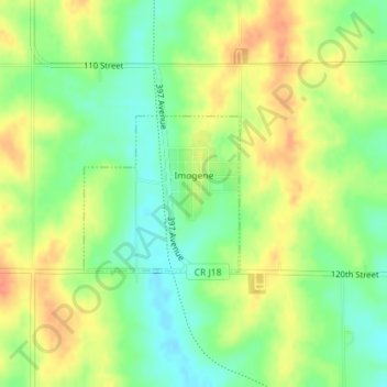
Name: Imogene topographic map, elevation, terrain.

Location: Imogene, Fremont County, Iowa, United States (40.87267 -95.43702 40.88356 -95.42260)

Average elevation: 1,093 ft

Minimum elevation: 1,020 ft

Maximum elevation: 1,165 ft

Fremont County trails, hiking, mountain biking, running and outdoor activities

Other topographic maps

Click on a map to view its topography, its elevation and its terrain.

Percival

United States > Iowa > Fremont County

Average elevation: 928 ft

McPaul

United States > Iowa > Fremont County

Average elevation: 935 ft

Bartlett

United States > Iowa > Fremont County

Average elevation: 945 ft

Anderson

United States > Iowa > Fremont County

Average elevation: 991 ft

Gear up for your next adventure:

🦶Hiking Gaiters - Keep debris and water out of your boots
🩹Survival Bandages - High‑quality bandages for emergencies
🥄Camping Utensil Set - Lightweight utensils for outdoor meals
🗻Climbing Gear Basics - Essential gear for beginner climbers
🔦Compact Flashlight - Reliable flashlight for emergencies

As an Amazon Associate, this site earns from qualifying purchases at no extra cost to you.