Geolocate

Kinsale topographic map

Click on the map to display elevation.

About this map

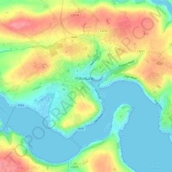
Name: Kinsale topographic map, elevation, terrain.

Location: Kinsale, County Cork, Munster, Ireland (51.69276 -8.54243 51.71578 -8.48970)

Average elevation: 118 ft

Minimum elevation: -10 ft

Maximum elevation: 299 ft

Other topographic maps

Click on a map to view its topography, its elevation and its terrain.

Model Village

Ireland > County Cork

Average elevation: 328 ft

Leamlara

Ireland > County Cork

Average elevation: 476 ft

Halfway

Ireland > County Cork

Average elevation: 315 ft

Lisgoold

Ireland > County Cork

Average elevation: 367 ft

Minane Bridge

Ireland > County Cork

Average elevation: 230 ft

Kilmichael

Ireland > County Cork

Average elevation: 436 ft

Macroom

Ireland > County Cork > Blarney - Macroom > Macroom

Average elevation: 377 ft

Lee Fields

Ireland > County Cork > Cork

Average elevation: 161 ft

Cobh

Ireland > County Cork > Cobh Municipal District > Cobh

Average elevation: 75 ft

Blarney

Ireland > County Cork > Blarney - Macroom > Blarney

Average elevation: 272 ft

Nad

Ireland > County Cork

Average elevation: 774 ft

Mitchelstown

Ireland > County Cork > Mitchelstown

Average elevation: 417 ft

Castletownbere

Ireland > County Cork > Castletownbere

Average elevation: 289 ft

Mount Gabriel

Ireland > County Cork

Average elevation: 564 ft

Gear up for your next adventure:

🦺Reflective Outdoor Gear - Safety gear for low‑light conditions
🚁Photography Drones - Capture stunning aerial views of landforms and topography
🗻Climbing Gear Basics - Essential gear for beginner climbers
📚USA Hiking Guide Books - Top trail guides and map books
🧢Outdoor Hiking Hat - Sun protection hat for outdoor explorers

As an Amazon Associate, this site earns from qualifying purchases at no extra cost to you.