Geolocate

Model Village topographic map

Click on the map to display elevation.

About this map

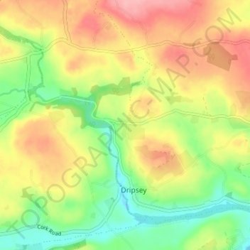
Name: Model Village topographic map, elevation, terrain.

Location: Model Village, Dripsey, Municipal District of Macroom, County Cork, Munster, Ireland (51.90530 -8.76427 51.94530 -8.72427)

Average elevation: 328 ft

Minimum elevation: 154 ft

Maximum elevation: 509 ft

Other topographic maps

Click on a map to view its topography, its elevation and its terrain.

Kilworth

Ireland > County Cork

Average elevation: 374 ft

Kilbrin

Ireland > County Cork

Average elevation: 502 ft

Kanturk

Ireland > County Cork

Average elevation: 404 ft

Midleton

Ireland > County Cork

Average elevation: 59 ft

Newmarket

Ireland > County Cork

Average elevation: 554 ft

Clonakilty

Ireland > County Cork

Average elevation: 135 ft

Macroom

Ireland > County Cork

Average elevation: 361 ft

Finnis

Ireland > County Cork

Average elevation: 246 ft

Ahildotia

Ireland > County Cork

Average elevation: 292 ft

Blarney

Ireland > County Cork

Average elevation: 210 ft

Watergrasshill

Ireland > County Cork

According to A Topographical Dictionary of Ireland, published by Samuel Lewis in 1837, Watergrasshill then had a population of 533 people.

Average elevation: 538 ft

Matehy

Ireland > County Cork

Average elevation: 351 ft

Coole East

Ireland > County Cork

Average elevation: 371 ft

Kilcully

Ireland > County Cork > Cork

Average elevation: 272 ft

Killumney

Ireland > County Cork

Average elevation: 259 ft

Kinsale

Ireland > County Cork

Average elevation: 118 ft

Innishannon

Ireland > County Cork

Average elevation: 177 ft

Carrigtwohill

Ireland > County Cork

Average elevation: 75 ft

Ballincurrig

Ireland > County Cork

Average elevation: 135 ft

Cloyne

Ireland > County Cork

Average elevation: 131 ft

Ballygarvan

Ireland > County Cork

Average elevation: 230 ft

Ballymore

Ireland > County Cork

Average elevation: 131 ft

Lee Fields

Ireland > County Cork > Cork

Average elevation: 161 ft

Knocknagree

Ireland > County Cork

Average elevation: 600 ft

Lackenroe

Ireland > County Cork > Cobh Municipal District

Average elevation: 289 ft

Desert

Ireland > County Cork

Average elevation: 128 ft

Gortnacarriga

Ireland > County Cork

Average elevation: 197 ft

Douglas

Ireland > County Cork > Cork

Average elevation: 112 ft

Gear up for your next adventure:

🪶Fire Starter Kit - Reliable fire starter for survival and camping
😴Insulated Sleeping Pads - Compact and warm pads for high-elevation camping
🎒Trekking Poles - Sturdy poles for balance and stability on rough terrain
🪶Multi‑Purpose Knife - Useful blade for camp and trail
🔦Compact Flashlight - Reliable flashlight for emergencies

As an Amazon Associate, this site earns from qualifying purchases at no extra cost to you.