Geolocate

Dordrecht topographic map

Click on the map to display elevation.

About this map

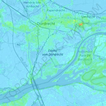
Name: Dordrecht topographic map, elevation, terrain.

Location: Dordrecht, South Holland, Netherlands (51.71412 4.62040 51.82336 4.88464)

Average elevation: 3 ft

Minimum elevation: -16 ft

Maximum elevation: 85 ft

Other topographic maps

Click on a map to view its topography, its elevation and its terrain.

Meije

Netherlands > South Holland > Nieuwkoop

Average elevation: -7 ft

Langeraar

Netherlands > South Holland

Average elevation: -10 ft

Broekhuizen

Netherlands > South Holland > Gouda

Average elevation: -3 ft

Ankerpark

Netherlands > South Holland > Leiden

Average elevation: 10 ft

Botlek

Netherlands > South Holland

Average elevation: 10 ft

Middelsluis

Netherlands > South Holland > Numansdorp

Average elevation: 0 ft

Weerestein

Netherlands > South Holland > Hillegom

Average elevation: 0 ft

Weerestein

Netherlands > South Holland > Hillegom

Average elevation: 0 ft

Meijendel

Netherlands > South Holland > Wassenaar

Average elevation: 20 ft

Coepelduynen

Netherlands > South Holland > Katwijk

Average elevation: 13 ft

Het Park

Netherlands > South Holland > Rotterdam

Average elevation: 13 ft

Waalhaven

Netherlands > South Holland > Rotterdam

Average elevation: 10 ft

Gear up for your next adventure:

🧣Hiking Neck Gaiter - Multi‑use neck protection for outdoor weather
🪶LED Camping Lantern - Bright lantern for camp lighting
🛶Inflatable Kayak - Portable kayak for rivers, lakes, and expeditions
🎒Day Hiking Backpack - Lightweight backpack perfect for day trips and outdoor adventures
🗃️Trail First Aid Kit - Essential kit for outdoor injuries and emergencies

As an Amazon Associate, this site earns from qualifying purchases at no extra cost to you.