
Make a donation
Gear up for your next adventure:
As an Amazon Associate, this site earns from qualifying purchases at no extra cost to you.
Annaberg-Lungötz topographic map
Click on the map to display elevation.
Make a donation
Gear up for your next adventure:
As an Amazon Associate, this site earns from qualifying purchases at no extra cost to you.
About this map
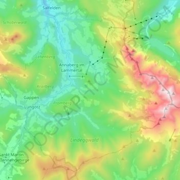
Name: Annaberg-Lungötz topographic map, elevation, terrain.
Location: Annaberg-Lungötz, Bezirk Hallein, Salzburg, Austria (47.45840 13.36765 47.54975 13.51618)
Average elevation: 3,983 ft
Minimum elevation: 2,238 ft
Maximum elevation: 7,802 ft
Make a donation
Gear up for your next adventure:
As an Amazon Associate, this site earns from qualifying purchases at no extra cost to you.
Other topographic maps
Click on a map to view its topography, its elevation and its terrain.
Alpendorf Dachstein West
Austria > Salzburg > Bezirk Hallein > Annaberg-Lungötz > Annaberg im Lammertal
Average elevation: 3,435 ft
Make a donation
Gear up for your next adventure:
As an Amazon Associate, this site earns from qualifying purchases at no extra cost to you.
Annaberg im Lammertal
Austria > Salzburg > Bezirk Hallein > Annaberg-Lungötz
Average elevation: 3,173 ft