Geolocate

Staffolo topographic map

Click on the map to display elevation.

About this map

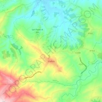
Name: Staffolo topographic map, elevation, terrain.

Location: Staffolo, Ancona, Marche, 60039, Italy (43.41360 13.14551 43.46682 13.24437)

Average elevation: 846 ft

Minimum elevation: 325 ft

Maximum elevation: 1,955 ft

Other topographic maps

Click on a map to view its topography, its elevation and its terrain.

Gabriella

Italy > Marche > Ancona > Senigallia

Average elevation: 138 ft

Gear up for your next adventure:

🪶Compact Camp Shovel - Folding shovel for campsite tasks
📦Dry Bags Set - Waterproof storage for electronics and clothes
🔋Solar Power Banks - Keep your GPS and phone charged in remote wilderness areas
🎒Day Hiking Backpack - Lightweight backpack perfect for day trips and outdoor adventures
🔪Outdoor Multitools - Essential survival tools for gear repair and field use

As an Amazon Associate, this site earns from qualifying purchases at no extra cost to you.