
Make a donation
Gear up for your next adventure:
As an Amazon Associate, this site earns from qualifying purchases at no extra cost to you.
Preglia topographic map
Click on the map to display elevation.
Make a donation
Gear up for your next adventure:
As an Amazon Associate, this site earns from qualifying purchases at no extra cost to you.
About this map
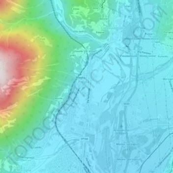
Name: Preglia topographic map, elevation, terrain.
Average elevation: 1,542 ft
Minimum elevation: 863 ft
Maximum elevation: 4,957 ft
Make a donation
Gear up for your next adventure:
As an Amazon Associate, this site earns from qualifying purchases at no extra cost to you.
Other topographic maps
Click on a map to view its topography, its elevation and its terrain.
Lake Maggiore
Italy > Piedmont > Verbano-Cusio-Ossola
Lake Maggiore weather is humid subtropical (Cfa in the Köppen climate classification). During winter, the lake helps to maintain a higher temperature in the surrounding region (since water releases heat energy more slowly than air). The temperatures are cooled down in summer by the breezes that blow on the…
Average elevation: 2,149 ft
Ghiacciaio del Belvedere
Italy > Piedmont > Verbano-Cusio-Ossola > Macugnaga
Average elevation: 7,254 ft
Make a donation
Gear up for your next adventure:
As an Amazon Associate, this site earns from qualifying purchases at no extra cost to you.
Make a donation
Gear up for your next adventure:
As an Amazon Associate, this site earns from qualifying purchases at no extra cost to you.