
Make a donation
Gear up for your next adventure:
As an Amazon Associate, this site earns from qualifying purchases at no extra cost to you.
Santa Maria Maggiore topographic map
Click on the map to display elevation.
Make a donation
Gear up for your next adventure:
As an Amazon Associate, this site earns from qualifying purchases at no extra cost to you.
About this map
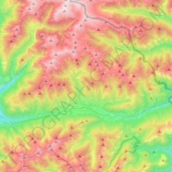
Name: Santa Maria Maggiore topographic map, elevation, terrain.
Location: Santa Maria Maggiore, Verbano-Cusio-Ossola, Piedmont, Italy (46.06974 8.41142 46.24954 8.49389)
Average elevation: 4,646 ft
Minimum elevation: 1,289 ft
Maximum elevation: 8,465 ft
Make a donation
Gear up for your next adventure:
As an Amazon Associate, this site earns from qualifying purchases at no extra cost to you.
Other topographic maps
Click on a map to view its topography, its elevation and its terrain.
Ghiacciaio del Belvedere
Italy > Piedmont > Verbano-Cusio-Ossola > Macugnaga
Average elevation: 7,254 ft
Make a donation
Gear up for your next adventure:
As an Amazon Associate, this site earns from qualifying purchases at no extra cost to you.
Make a donation
Gear up for your next adventure:
As an Amazon Associate, this site earns from qualifying purchases at no extra cost to you.
Alpe Cheggio
Italy > Piedmont > Verbano-Cusio-Ossola > Antrona Schieranco > Alpe Cheggio
Average elevation: 6,004 ft