Geolocate

Whitesburg topographic map

Click on the map to display elevation.

About this map

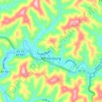
Name: Whitesburg topographic map, elevation, terrain.

Location: Whitesburg, Letcher County, Kentucky, United States (37.10708 -82.85159 37.13676 -82.78998)

Average elevation: 1,463 ft

Minimum elevation: 1,109 ft

Maximum elevation: 2,034 ft

Letcher County trails, hiking, mountain biking, running and outdoor activities

Other topographic maps

Click on a map to view its topography, its elevation and its terrain.

Mayking

United States > Kentucky > Letcher County

Average elevation: 1,470 ft

Roxana

United States > Kentucky > Letcher County

Average elevation: 1,394 ft

Seco

United States > Kentucky > Letcher County

Average elevation: 1,509 ft

Ice

United States > Kentucky > Letcher County

Average elevation: 1,460 ft

Eolia

United States > Kentucky > Letcher County

Average elevation: 2,008 ft

Gear up for your next adventure:

🪶Thermal Camp Blanket - Extra warmth for cold nights
🧦Merino Wool Socks - Moisture-wicking, blister-preventing socks for long treks
🧷Carabiner Set - Durable clips for gear attachment
🏕️Family Camping Gear - Essentials for group camping trips
👟Trail Running Shoes - Lightweight shoes for trail runners

As an Amazon Associate, this site earns from qualifying purchases at no extra cost to you.