Geolocate

Alcabideche topographic map

Click on the map to display elevation.

About this map

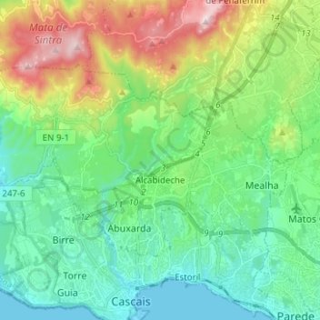
Name: Alcabideche topographic map, elevation, terrain.

Location: Alcabideche, Cascais, Lisbon, Portugal (38.71050 -9.48377 38.76899 -9.35897)

Average elevation: 469 ft

Minimum elevation: 0 ft

Maximum elevation: 1,647 ft

Other topographic maps

Click on a map to view its topography, its elevation and its terrain.

Parque Urbano Outeiro da Vela

Portugal > Lisbon > Cascais

Average elevation: 144 ft

Atrozela

Portugal > Lisbon > Cascais

Average elevation: 397 ft

Biscaia

Portugal > Lisbon > Cascais

Average elevation: 538 ft

Casal da Serra

Portugal > Lisbon > Cascais

Average elevation: 394 ft

São Jorge de Oitavos

Portugal > Lisbon > Cascais

Average elevation: 69 ft

Malveira da Serra

Portugal > Lisbon > Cascais

Average elevation: 594 ft

Gear up for your next adventure:

🚪Portable Camp Chair - Foldable chair for comfort at camp
🥤Water Filter Bottle - All‑in‑one filter bottle for safe hydration
📡Handheld GPS Device - Reliable handheld GPS for outdoor navigation
GPS Sports Watch - GPS watch for running, hiking and training
🧭Outdoor Navigation Book - Learn advanced navigation skills

As an Amazon Associate, this site earns from qualifying purchases at no extra cost to you.