Geolocate

Biscaia topographic map

Click on the map to display elevation.

About this map

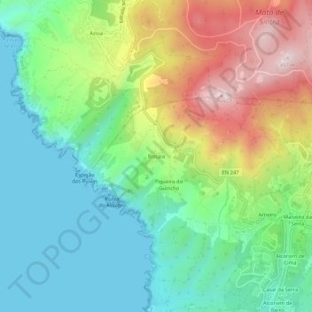
Name: Biscaia topographic map, elevation, terrain.

Location: Biscaia, Alcabideche, Cascais, Lisbon, 2705-001, Portugal (38.74069 -9.49137 38.78069 -9.45137)

Average elevation: 538 ft

Minimum elevation: -7 ft

Maximum elevation: 1,562 ft

Other topographic maps

Click on a map to view its topography, its elevation and its terrain.

Estoril

Portugal > Lisbon > Cascais

Average elevation: 161 ft

Carcavelos

Portugal > Lisbon > Cascais

Average elevation: 118 ft

Parque Urbano Outeiro da Vela

Portugal > Lisbon > Cascais

Average elevation: 144 ft

Parede

Portugal > Lisbon > Cascais

Average elevation: 121 ft

Atrozela

Portugal > Lisbon > Cascais

Average elevation: 397 ft

Alcabideche

Portugal > Lisbon > Cascais

Average elevation: 469 ft

Estoril

Portugal > Lisbon > Cascais

Average elevation: 161 ft

Alcabideche

Portugal > Lisbon > Cascais

Average elevation: 469 ft

Gear up for your next adventure:

🩹Survival Bandages - High‑quality bandages for emergencies
🥩Freeze-Dried Meals - Nutritious and lightweight food for remote expeditions
🛰️Handheld GPS Units - Professional satellite navigators for precise backcountry mapping
🪓Survival Multi‑Tool - Versatile tool for camp and trail tasks
☀️Outdoor Sunscreen - High protection sunscreen for outdoor activities

As an Amazon Associate, this site earns from qualifying purchases at no extra cost to you.