
Make a donation
Gear up for your next adventure:
As an Amazon Associate, this site earns from qualifying purchases at no extra cost to you.
Alfarnatejo topographic map
Click on the map to display elevation.
Make a donation
Gear up for your next adventure:
As an Amazon Associate, this site earns from qualifying purchases at no extra cost to you.
Alfarnatejo
La majorité de la population est situé à 898 mètres d'altitude. La ville entourée par le "Pic de Chamizo" (1,637 m), celui du "Gallo" (1,356 m) et le "Vilo" (1,412 m). Dans la municipalité, "los Altos del Fraile" (1,222 m) et de "Doña Ana" (1,188 m).
Make a donation
Gear up for your next adventure:
As an Amazon Associate, this site earns from qualifying purchases at no extra cost to you.
About this map
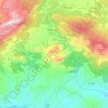
Name: Alfarnatejo topographic map, elevation, terrain.
Location: Alfarnatejo, La Axarquía, Malaga, Andalousie, Espagne (36.93470 -4.31082 36.98956 -4.21691)
Average elevation: 2,772 ft
Minimum elevation: 1,217 ft
Maximum elevation: 5,341 ft
Make a donation
Gear up for your next adventure:
As an Amazon Associate, this site earns from qualifying purchases at no extra cost to you.
Other topographic maps
Click on a map to view its topography, its elevation and its terrain.
Castillo de Benthomiz
Espagne > Andalousie > La Axarquía > Arenas
Le château de Bentomiz, est une ancienne forteresse construite sur un coteau, proche du village espagnol d'Arenas, dans la province andalouse de Malaga, à 711 mètres d'altitude. Cette forteresse notée sur un document signé par Abd Allah, roi zirí de Grenade au XI siècle, fut reprise par le roi…
Average elevation: 1,411 ft
Make a donation
Gear up for your next adventure:
As an Amazon Associate, this site earns from qualifying purchases at no extra cost to you.
Las Casillas
Espagne > Andalousie > La Axarquía > Rincón de la Victoria > Las Casillas
Average elevation: 299 ft