Geolocate

McKee topographic map

Click on the map to display elevation.

About this map

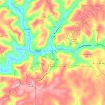
Name: McKee topographic map, elevation, terrain.

Location: McKee, Jackson County, Kentucky, United States (37.41478 -84.01397 37.44407 -83.96026)

Average elevation: 1,266 ft

Minimum elevation: 988 ft

Maximum elevation: 1,457 ft

Jackson County trails, hiking, mountain biking, running and outdoor activities

Other topographic maps

Click on a map to view its topography, its elevation and its terrain.

Wind Cave

United States > Kentucky > Jackson County

Average elevation: 1,119 ft

Tyner

United States > Kentucky > Jackson County

Average elevation: 1,253 ft

Annville

United States > Kentucky > Jackson County

Average elevation: 1,178 ft

Wind Cave

United States > Kentucky > Jackson County

Average elevation: 1,119 ft

Annville

United States > Kentucky > Jackson County

Average elevation: 1,178 ft

Gear up for your next adventure:

🗺️Topographic Maps - Detailed topo maps for hiking, exploring and outdoor navigation
🔦Compact Flashlight - Reliable flashlight for emergencies
🧦Hiking Socks - Comfortable socks to prevent blisters on long hikes
👓Polarized Sunglasses - Outdoor sunglasses for glare reduction
🖼️Topo Map Wall Art - Decorative topographic prints of famous peaks and regions

As an Amazon Associate, this site earns from qualifying purchases at no extra cost to you.