Geolocate

Negley topographic map

Click on the map to display elevation.

About this map

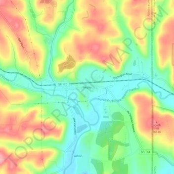
Name: Negley topographic map, elevation, terrain.

Location: Negley, Columbiana County, Ohio, 44441, United States (40.77006 -80.55896 40.81006 -80.51896)

Average elevation: 984 ft

Minimum elevation: 804 ft

Maximum elevation: 1,198 ft

Columbiana County trails, hiking, mountain biking, running and outdoor activities

Other topographic maps

Click on a map to view its topography, its elevation and its terrain.

Salem

United States > Ohio > Columbiana County

Average elevation: 1,230 ft

Columbiana

United States > Ohio > Columbiana County

Average elevation: 1,135 ft

Lisbon

United States > Ohio > Columbiana County

Average elevation: 1,096 ft

Fairfield Township

United States > Ohio > Columbiana County

Average elevation: 1,171 ft

East Liverpool

United States > Ohio > Columbiana County

Average elevation: 997 ft

East Palestine

United States > Ohio > Columbiana County

Average elevation: 1,119 ft

Salem

United States > Ohio > Columbiana County

Average elevation: 1,230 ft

Gear up for your next adventure:

🪶Paracord Bracelet - Survival bracelet with built‑in tools
🏔️Mountain Trail Maps - High‑detail maps for popular peaks
🔊Portable Camp Speaker - Music and alerts at camp
Backpacking Tent - Lightweight and durable tent for multi‑day hikes
🦟Ultrasonic Repellers - Create a bug-free zone at your camp or rest stop

As an Amazon Associate, this site earns from qualifying purchases at no extra cost to you.