Geolocate

Salem topographic map

Click on the map to display elevation.

About this map

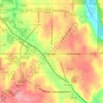
Name: Salem topographic map, elevation, terrain.

Location: Salem, Columbiana County, Ohio, 44460, United States (40.87894 -80.89014 40.92558 -80.81123)

Average elevation: 1,230 ft

Minimum elevation: 1,010 ft

Maximum elevation: 1,388 ft

Columbiana County trails, hiking, mountain biking, running and outdoor activities

Other topographic maps

Click on a map to view its topography, its elevation and its terrain.

Negley

United States > Ohio > Columbiana County

Average elevation: 984 ft

Valley

United States > Ohio > Columbiana County

Average elevation: 1,234 ft

Valley

United States > Ohio > Columbiana County

Average elevation: 1,234 ft

North Georgetown

United States > Ohio > Columbiana County

Average elevation: 1,171 ft

Gear up for your next adventure:

🌧️Backpack Rain Cover - Keep gear dry in wet weather
📦Gear Storage Bags - Organize and protect outdoor equipment
🪶Camp Gear Gift Set - Perfect gift bundle for outdoor fans
🩳Quick‑Dry Hiking Shorts - Comfortable and quick‑dry shorts for summer hiking
🛶Inflatable Kayak - Portable kayak for rivers, lakes, and expeditions

As an Amazon Associate, this site earns from qualifying purchases at no extra cost to you.