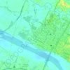
Badoc topographic map
Click on the map to display elevation.
Badoc
The celebrated Philippine painter Juan Luna was baptized in Badoc Church on 27 October 1857. At present, the church houses the miraculous statue of the Blessed Virgin Mary venerated under the title Virgin of Miracles, crowned by Catholic bishops in 1980, and was granted a Canonical coronation by Pope Francis on 31 May 2018. On November 30, 2018, the parish was elevated to the level of a Minor Basilica. The elevation rites took place on February 5, 2019.
About this map

Name: Badoc topographic map, elevation, terrain.
Location: Badoc, Ilocos Norte, Ilocos Region, 2733, Philippines (17.88670 120.43409 17.96670 120.51409)
Average elevation: 66 ft
Minimum elevation: 0 ft
Maximum elevation: 308 ft
Other topographic maps
Click on a map to view its topography, its elevation and its terrain.
Pagudpud
The town's topography includes mountains, hills, valleys and flat coastal land.
Average elevation: 240 ft


La Paz Sand Dunes
Philippines > Ilocos Norte > Brgy. 62-B Navotas South > Laoag
Average elevation: 23 ft

Pagudpud
The topography includes mountains, hills, valleys, and flat coastal land. Maira-ira Beach is the northernmost tip of Luzon Island, located at 18°33′34″N 120°47′15″E / 18.55944°N 120.78750°E / 18.55944; 120.78750 on the Luzon Strait.
Average elevation: 240 ft
Pagudpud
The topography includes mountains, hills, valleys, and flat coastal land. Maira-ira Beach is the northernmost tip of Luzon Island, located at 18°33′34″N 120°47′15″E / 18.55944°N 120.78750°E / 18.55944; 120.78750 on the Luzon Strait.
Average elevation: 240 ft

Pagudpud
The town's topography includes mountains, hills, valleys and flat coastal land.
Average elevation: 240 ft