Geolocate

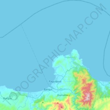
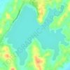
Pagudpud topographic map

Click on the map to display elevation.

Pagudpud

The town's topography includes mountains, hills, valleys and flat coastal land.

Wikipedia (CC-BY-SA 3.0)

About this map

Name: Pagudpud topographic map, elevation, terrain.

Location: Pagudpud, Ilocos Norte, Ilocos Region, 2919, Philippines (18.47765 120.68419 18.79030 120.97121)

Average elevation: 233 ft

Minimum elevation: -3 ft

Maximum elevation: 4,167 ft

Other topographic maps

Click on a map to view its topography, its elevation and its terrain.
Pasuquin

Philippines > Ilocos Norte

Average elevation: 164 ft

Batac

Philippines > Ilocos Norte

Average elevation: 174 ft

Bacarra

Philippines > Ilocos Norte

Average elevation: 79 ft

Bangui

Philippines > Ilocos Norte

Average elevation: 236 ft

Brgy. 58- Casili

Philippines > Ilocos Norte

Average elevation: 33 ft

Suyo

Philippines > Ilocos Norte > Dingras

Average elevation: 128 ft

Solsona

Philippines > Ilocos Norte

Average elevation: 207 ft

Tangid

Philippines > Ilocos Norte > Laoag

Average elevation: 30 ft

Paoay Lake

Philippines > Ilocos Norte > Suba

Average elevation: 85 ft

Poblacion 2

Philippines > Ilocos Norte > Pagudpud

Average elevation: 39 ft

Suba

Philippines > Ilocos Norte

Average elevation: 92 ft

Gear up for your next adventure:

🧣Merino Neck Gaiters - Multi-functional headwear for wind and sun protection
⛑️Personal Locator Beacon - Safety beacon for emergencies
👓Polarized Sunglasses - Outdoor sunglasses for glare reduction
🎒Trail Energy Bars - High‑calorie bars for hiking energy
📡Handheld GPS Device - Reliable handheld GPS for outdoor navigation

As an Amazon Associate, this site earns from qualifying purchases at no extra cost to you.