Geolocate

Waring topographic map

Click on the map to display elevation.

About this map

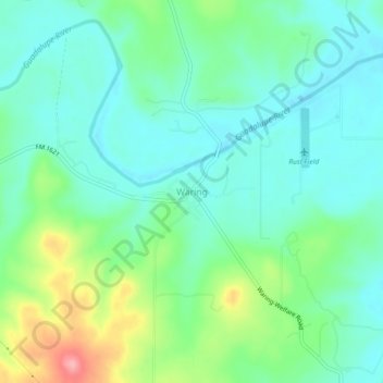
Name: Waring topographic map, elevation, terrain.

Location: Waring, Kendall County, Texas, 78074, United States (29.93144 -98.82421 29.97144 -98.78421)

Average elevation: 1,394 ft

Minimum elevation: 1,293 ft

Maximum elevation: 1,670 ft

Kendall County trails, hiking, mountain biking, running and outdoor activities

Other topographic maps

Click on a map to view its topography, its elevation and its terrain.

Boerne

United States > Texas > Kendall County

Average elevation: 1,526 ft

Gear up for your next adventure:

💧Water Purification System - Clean water on the trail with reliable purifiers
🧯Portable Fire Pit - Compact fire pit for camping spots
🔭Compact Binoculars - HD vision for scouting terrain and identifying distant landmarks
🏕️Tent Footprint - Protect your tent base from wear
🪄Magnetic Compass - Accurate compass for navigation

As an Amazon Associate, this site earns from qualifying purchases at no extra cost to you.