Geolocate

Boerne topographic map

Click on the map to display elevation.

About this map

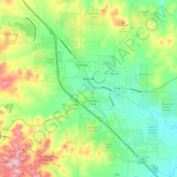
Name: Boerne topographic map, elevation, terrain.

Location: Boerne, Kendall County, Texas, United States (29.74552 -98.80201 29.83211 -98.68245)

Average elevation: 1,526 ft

Minimum elevation: 1,306 ft

Maximum elevation: 1,890 ft

Kendall County trails, hiking, mountain biking, running and outdoor activities

Other topographic maps

Click on a map to view its topography, its elevation and its terrain.

Walnut Grove

United States > Texas > Kendall County

Average elevation: 1,493 ft

Bergheim

United States > Texas > Kendall County

Bergheim is an unincorporated community in eastern Kendall County, Texas, United States known for its German-Texan culture and heritage. It lies along State Highway 46 east of the city of Boerne, the county seat of Kendall County. Its elevation is 1,437 feet (438 m). Although Bergheim is unincorporated, it has…

Average elevation: 1,375 ft

Kreutzberg

United States > Texas > Kendall County

Average elevation: 1,398 ft

Waring

United States > Texas > Kendall County

Average elevation: 1,394 ft

Gear up for your next adventure:

🥾Men's Hiking Boots - Durable, waterproof footwear for rugged terrain and steep inclines
🏔️Mountain Trail Maps - High‑detail maps for popular peaks
📖Nature Tracking Books - Learn to track wildlife and terrain
🏕️Family Camping Gear - Essentials for group camping trips
📷Action Cameras - Rugged cameras to document your journeys across rugged terrain

As an Amazon Associate, this site earns from qualifying purchases at no extra cost to you.