Geolocate

Hudson topographic map

Click on the map to display elevation.

About this map

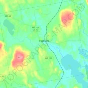
Name: Hudson topographic map, elevation, terrain.

Location: Hudson, Penobscot County, Maine, 04449, United States (44.94391 -68.95823 45.05045 -68.80778)

Average elevation: 174 ft

Minimum elevation: 102 ft

Maximum elevation: 371 ft

Penobscot County trails, hiking, mountain biking, running and outdoor activities

Other topographic maps

Click on a map to view its topography, its elevation and its terrain.

Lincoln

United States > Maine > Penobscot County > Lincoln

Average elevation: 272 ft

Houston Island

United States > Maine > Penobscot County > Winn

Average elevation: 243 ft

Carroll

United States > Maine > Penobscot County

Average elevation: 778 ft

Fairmont Park

United States > Maine > Penobscot County > Bangor

Average elevation: 148 ft

Meadow Brook

United States > Maine > Penobscot County

Average elevation: 325 ft

Gear up for your next adventure:

🎒Waterproof Dry Bags - Keep your electronics and maps dry inside your pack
🪶Paracord Bracelet - Survival bracelet with built‑in tools
🔌USB Car Charger - Car charger for on‑the‑go power needs
🪑Ultralight Camp Chairs - Portable seating for resting after a long day of mapping
🪶Trail Camera - Capture wildlife on your hikes

As an Amazon Associate, this site earns from qualifying purchases at no extra cost to you.