
Make a donation
Gear up for your next adventure:
As an Amazon Associate, this site earns from qualifying purchases at no extra cost to you.
Bienenwerder topographic map
Click on the map to display elevation.
Make a donation
Gear up for your next adventure:
As an Amazon Associate, this site earns from qualifying purchases at no extra cost to you.
About this map
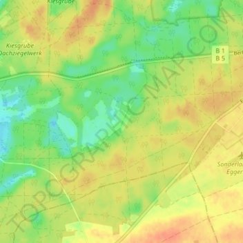
Name: Bienenwerder topographic map, elevation, terrain.
Average elevation: 207 ft
Minimum elevation: 141 ft
Maximum elevation: 256 ft
Make a donation
Gear up for your next adventure:
As an Amazon Associate, this site earns from qualifying purchases at no extra cost to you.
Other topographic maps
Click on a map to view its topography, its elevation and its terrain.
Maxsee
Deutschland > Brandenburg > Märkisch-Oderland > Müncheberg > Maxseesiedlung
Laut Datenerhebung des Instituts für angewandte Gewässerökologie Brandenburg aus dem Jahr 2001 ergeben sich folgende topographische, morphometrische und limnologische Werte für den Maxsee: die maximale Tiefe des Gewässers beträgt vier, die mittlere Tiefe rund zwei Meter. Der von Nordost nach Südwest…
Average elevation: 171 ft